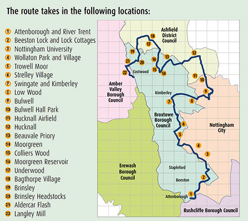
Broxtowe Country Trail

Trail Information
| Information Type | Details |
|---|---|
| Route Type |
Linear Walk/Cycle |
| Distance |
27 Miles |
| Surface and Gradients |
Path surfaces a generally in a good condition and reasonably level though there are a few steep sections. |
| Parking Nearby |
Yes |
| On Bus Routes |
Yes |
| Wheelchair Friendly |
Much of the route has reasonably level access, however, there are steep sections and controls such as kissing gates and other features at some locations. |
| Map |
View Broxtowe Country Trail Map and Guide (.pdf) (5.92MB) (Opens in a New Window) |
| Extra Information |
Walkers should expect to share sections of the route with cyclists and horse riders. |
Trail Description
The trail was conceived and developed through a partnership led by Broxtowe Borough Council, Nottingham City Council, and Nottinghamshire County Council. Other partners included Nottinghamshire Wildlife Trust, Sustrans , Ridewise, Ashfield District Council, Derbyshire County Council, Amber Valley Borough Council and Pedals.
The trail uses existing routes to produce a long distance trail which roughly follows the boundary between Broxtowe Borough and Nottingham City.
The trail:
- Provides a 27 mile walking and cycling route taking in some of the most attractive countryside in Nottinghamshire.
- Connects communities and encourages those living on the urban fringe to explore the local countryside using short local routes.
- Provides a shared identity and encourages local pride. It helps to define the difference between Broxtowe Borough Council and the area of Broxtowe which is within the city. The two are often confused.
- The trail highlights local honey pot features such as Attenborough Nature Centre, DH Lawrence Museum and Wollaton Hall as well as connections to more distant features such as Papplewick , Ashfields Hidden Valleys, and Shipley Park.
- Helps to promote the wildlife sites and the general wildlife features in the area. Mapping shows Local Nature Reserves as well as the larger features such as the Moorgreen Reservoir and Attenborough Nature Reserve.
- Connects with the Erewash Valley Trail creating the opportunity to cycle the whole boundary of the Borough of Broxtowe a distance of about 40 miles.


